MUGHAL TOMB PLANNING

Hindustan, back in the 16th century was conquered by the descendants of one of the most accomplished military forces of Asia, The Mongols, or The Mughals. These dynasts, like every other great ruler, yearned to live through time. And what better way was there than to commission work for buildings of monumental value. Religious sanctuaries, palaces, forts, step-wells, and even mausoleums, most of which served the royal family more than the locals. 

Mughal’s checklist of architectural delicacies, that their very own tombs should have, was very innate. Therefore, it led to the curation of a new building typology with a subjective planning system in itself. They called them Maqbara or Mausoleums. A wonderment of a blockade where they wished to rest after their demise.

This image has an empty alt attribute; its file name is shalvi-raj-qun1pdo6wim-unsplash.jpg
The Muqarnas Above a Corner Grave Niches’ Spandrels
Taj Mahal : White Marble, Red Sandstone, Black Onyx, Semi-Precious Gems ©Meriç Dağlı

This reflected the intervention of a completely new culture, with a foreign religion and even new techniques of construction. Such things weren’t an everyday groove. Indian artists and sculptors were now forced to work on a new language of architecture. A style migrating from Persia, their new masters’ homeland. The finest of the artisans and the brightest of the stones were used. There was no such thing as an excess decoration or rather a costly construction. After all, everything was an expensive affair in love and war!

Mughal tomb planning evolved over the reigns of the rulers, some elements kept on being added, while some got modified. The resultant of all this mental imagery resonated in great structures with highly specific workmanship. Here lie the list-down entities that made them funerary houses of these rulers.

MULTIAXIAL PLANS 

These tombs were inspired by mausoleums built during Delhi Sultanate. Originally standing on a simple square plan, architects and mathematicians started experimenting with complex geometry. The plan to be cast out was drawn in a 1:2 aspect ratio of two recurring squares one above the other. The plinth, stationed at a considerable height served as the base square holding the entire building on it. It made the base built-up geometry of the monument. Inside plans were an amalgamation of squares and polygons. This served as a multi-axial layout conceptualized by the Panch ratan combination. Crowned with domes and supporting arches, they were systematically highlighted as five chambers of spatial importance.

Tomb Plans showing multiple lines of symmetry. In order from left to right: Humayun’s Tomb, Akbar’s Tomb, Imtiad-ud-Daula’s Tomb and Taj Mahal ©History, Morphology and Perfect Proportions of Mughal Tombs: The Secret to Creation of Taj Mahal. Archnet-IJAR : International Journal of Architectural Research.
Multi Axial building form: Humayun’s Tomb, New Delhi ©Sanjeev Malhotra

GEOMETRY

Design in their contemporary times heavily rested on Balance and Symmetry. Builders evolved designs within the boundary of triangulation, scale, and proportions. Each level was marked, and crafted with special articulation to make it either stand out or seamlessly blend in. Symmetry being their chief ingredient, they outshone themselves as and when they were meant to. 

Building proportions and planning. In order from left to right: Humayun’s Tomb, Akbar’s Tomb, Imtiad-ud-Daula’s Tomb and Taj Mahal ©History, Morphology and Perfect Proportions of Mughal Tombs: The Secret to Creation of Taj Mahal. Archnet-IJAR : International Journal of Architectural Research.

The structural morphology was a result of the placement of architectural elements like arcades and pavilions in repetition. A rhythm was seen with an array of niches, brackets, and inlay motifs. 

DOUBLE DOMES WITH FINIALS

Magnanimous scale of the Taj Mahal with Double Dome and balconies ©Roberto Reposo

The interplay of levels and height of buildings dated back to the construction of some Lodhi tombs. The scale of the building was considered directly proportional to the command or grandeur of the built structure or even the Emperor for say. So to cast an elevation that could be appreciated from a distance far off and do well when experiencing the enclosure, architects came up with solutions: a rectilinear and raised plinth and Doble Domes. 

A dome, more than the height of double-storeyed interiors did not provide the kind of theatrics which was intended. While placed as per the levels it set well with the indoors, the dome could not be seen as a quality to the entire built mass from the outside. This is where the Double dome came in. The outer onion dome, which was to be visible from the outside was nothing but a shell. Volumetrically empty and supported by the dome below it. 

A finial was placed on its tip, shaped in from copper or brass. They were made to be 18 to 25 ft tall pointing towards the sky with symbols and patterns from Islam.

MUQARNAS AND DOUBLE HEIGHT SPACES

Facade Richness with Maqarna decoration on Akbar’s Tomb in Sikandra © http://www.adaagra.in/Sikandra.html
Maqarnas inside Imtiad-ud-Daula’s Tomb ©Pinterest

Used primarily to form smooth visual transitions between straight walls and domed rooms, Muqarnas add half the fandangles to the interiors. The surface richness embellished in every motif on these grace more of cosmetic purposes rather than structural. They are the surface covers to niches, squinches, and pendentives supporting arched framing of the interiors. Stationed at the dual height tiers of the building, they can be glanced at in their entirety and can witness how such forms fill in the volume of the space. 

MINARETS

Minarets are vertical structures of height that are meant to call out Prayer in Islamic Architecture. Although these towers were introduced in the later developments of such monuments, it holds a stance of value in religious buildings like Mosques. However, in Mausoleums, they act as the most prominent sleek and upended members in elevation. They are capped with balconies or jharokhas with a spire on top, stacked on with three or four tiers of marble course-work on their cylindrical shaft that cased spiral staircase. Each tier is tapering and has visible separations with intricate brackets. 

Imtiad-ud-Daula ‘sTomb: Stout Minarets at corners ©Muhammad Mahdi Karim

These towers were sometimes placed at the ends ( in Imtiad-ud-Daula’s Tomb ) or mesially ( as in Akbar’s Tomb). Taj Mahal, inspired by these two, detached its minars and shifted them to rest on the edge of the plinth to counterweight the otherwise built block of the tomb. They were also inclined outside to correct visual illusion. This bent, in the case of earthquakes, would fall outside the plinth, leaving the resting sanctuary unharmed. 

CHAR BAGH

The square Charbagh concept is interpreted as the four gardens of Paradise mentioned in the Quran. The two perpendicular partitions intersected in the center of the large square where the mausoleum was situated. Otherwise, a fountain sat in the middle. These gardens had run-across water channels as they were symbolic to the ‘Gardens underneath which rivers flow’. A complementing arrangement of plantations through-out the grass cover acted as guides to the path to the wonder that awaited the visitors’ appearance. They act as a built-up walkway offering views of the building, tier-by-tier, as its mammoth scale rises significantly for a person to endure. These garden complexes therefore also naturalize the scale of the buildings and weave a surrounding such that the building gets the highlight while not looking out of context with neighboring settlements of commoners.

Site Plans in order from left to right: Humayun’s Tomb, Akbar’s Tomb, Imtiad-ud-Daula’s Tomb and Taj Mahal ©History, Morphology and Perfect Proportions of Mughal Tombs: The Secret to Creation of Taj Mahal. Archnet-IJAR : International Journal of Architectural Research.

Apart from robust battle endeavors, The Mughals reposited to being called The Great Mughals majorly because of their artistic achievements. They considered these edified megaliths to speak of their grandeur and fame through time. No stone was left unturned or rather unfinished. Mughal emperors were ardent builders and halting at their crematorial building-scape on our Highway to Beyond made the journey all the more ceremonial. 

REFERENCES

  • Uplekar Krusche, Krupali & Danny, Aijian & Anders, Selena & Iva, Dokonal & Jill, Kapadia. (2010). History, Morphology and Perfect Proportions of Mughal Tombs: The Secret to Creation of Taj Mahal. Archnet-IJAR : International Journal of Architectural Research. 4. 10.26687/archnet-ijar.v4i1.69. 
  • Uplekar Krusche, Krupali & Danny, Aijian & Anders, Selena & Iva, Dokonal & Jill, Kapadia. (2010). History, Morphology and Perfect Proportions of Mughal Tombs: The Secret to Creation of Taj Mahal. Archnet-IJAR : International Journal of Architectural Research. 4. 10.26687/archnet-ijar.v4i1.69. 
  • Nangia, Ashish. “The Mughal Empire: Mosques and Tombs – I by Ashish Nangia.” Boloji.com, http://www.boloji.com/articles/989/the-mughal-empire-mosques-and-tombs–i.

7 Natural Wonders of India

Indian subcontinent, is blessed with multitudes of geological features. It is surrounded by water bodies from the three sides and is thus known to be a peninsula. With such geographical coordinates, various land-forms have roots here ever since a million years. The country itself is a Wonderland. Listed here are seven of the natural marvels this nation is jeweled with.

1. REVERSE WATER FALL, MAHARASHTRA

Source

A cliff, 122 km away from Pune’s scorching routine projects a waterfall of an unusual kind. This waterfall lies in the Naneghat pass behaves conversely to our natural perception of its kind; it splashes water upwards. The wind speed and the pressure generated by it against the mountain chunk is so powerful that the updraft makes the water flow upstream.

This distinctive event can only be seen during Monsoon. That time of the year dyes the entire region in covers of green. Fauna of different kinds, simply living their time in nature is a sight to behold.

Standing near to the fencing above the waterfall, the droplets diverted upwards feel like rain. Clouds at that height clash with the cliff and make the entire experience truly phenomenal.

2. LIVING ROOT BRIDGE, MEGHALAYA

Source

Meghalaya is one of the most blessed nooks on Earth with picturesque panoramas. The place is a carol of what a wonderment Nature is.

Apart from receiving the most amount of rainfall on the globe, it also houses special kinds of bridges.

Crafted with knots of Rubber tree roots, some bridges have hung for over 180 years. These are grown by trained Khasi and Jaintia tribes of the region. 

These are ever-evolving 30 m long bridges entangled of FICUS ELASTICA TREES (Rubber trees). Variety lies in its composite tiers. There are double-decker bridges in Cherapunjee and single-decker bridges in Shillong.

This place demands a trek for someone to see this wonder at work.

3. ST. MARY ISLAND, KARNATAKA

Source

St. Mary is considered the halt point of Vasco Da Gama before arriving at Calicut. He fixated a statue thereby giving this place the name of Mary. This crook of the landmass has four significant groups of islands. Among them, the northmost one had hinges of hexagonal pipe-like lava structures. These columnar basaltic crystallizations are also listed as a National Geological Monument.

The locus of the lava flow and its quick cooling in layers superseding each other formed these iconic structures. Units are seen in polygonal shapes with six, and more sides. Its blackish glint in lattice arrangement gives it an identity. It is one of its kind in India.

4. WHITE SALT DESERT, GUJARAT

Source

World’s largest salt marsh, with an area of 7500 square meters spans white over the later part of Thar desert in Kutch (Gujarat). It is usually known as White Rann of Kutch.

Unlike any conventional desert, it has no sand/salt dunes, no dust storms or any of the signature cacti. The land was once a part of Arabian sea, but due to a slight geological reform, this landmass rose 51m above the sea level. The high concentration of salt is also a major business for salt farmers of this area.

The lengths and breadth of this white territory is covered in salt and looks as if the entire place was bleached fabric. Blue sky and white land, a monotony one can only encounter while standing there.

The place is often visited in winter and is pumped with tourists during the three-month long Rann Utsav.    

CHIR BATTI

A little drive into the mainland Gujrat, one reaches the Banni grasslands. The pasture where Chir Batti or ‘Ghost Lights’ are very commonly seen after 8pm.

They resemble pear-shaped mercury lamps and are balls of fire. In colors of red, white, blue and yellow. Somedays they are stationary while they are also known to be moving with a speed of an arrow.

Source

This ‘Ignis Fatui’ is often caused by the oxidation of phosphine, diphosphine and methane. On organic decay, they are subjected to emit photons, thus the light. But locals believe that they are ghost of the dead residents of the village. However, the lights have never been known of harming any liveform.

5. MAGNETIC HILL, JAMMU & KASHMIR

Source

A point on a certain hill in Ladakh is known to be charmed. It is seen that when a car, left on neutral is kept in a white box marked there, it starts moving upwards on the hill, against the gravity.

While all of this is an optical illusion painted by the landscape there. These types of hills are called Cyclop hills. The surrounding topography is placed such that the downhill road looks like it goes up. The incline of the road in reality is quite the opposite of what a person can see standing there, thereby thinking his car just defied gravity. So when a car is left at neutral, it appears as it is moving uphill because of a magnetic force (against gravity) while it actually is moving downhill.

6. LONAR CRATER LAKE, MAHARASHTRA

Source

Around 52,000 years ago, a Meteorite crashed on the surface of Earth and marked a slump on the crust. This turned into a beautiful 150 m deep lake with rings of trees around its circumference.

The lake is known to be both saline as well as alkaline in nature. The water looks green, however in June 2020 it looked rose-pink for a period of days. The reason is still not known. It is being guessed that due to excess of salt, an algae turns to pink, just like Hillier Lake in Australia which is pink all the time.

Lonar Crater lake is a paradise for bird watchers as it is pays homage to many migratory birds and also houses specific endemic microbes and species found nowhere else on earth.  


7. MAJULI ISLAND, ASSAM

Majoli was originally a stretch of land between Brahmaputra and Burhidihing river, but after a series of earthquakes for years (1661-1696) and a 15 day-long flood in 1750, a large river island was formed. With an expanse of 880 square km, Majuli is also the first island district in India.

Standing alone, in the middle of the vast width of the Brahmaputra river, this island attracts more foreign tourists than locals. This little mass of land is saturated with culture. Traditional mask-making and the finest boat modeling during festivals is what this place is known for locally. Internationally, it is recognized as the World’s largest River Island in the Guinness Book of World Records.

Unlike other populous regions in India that wither at the threat of Pollution, this area is continuously receding its cover due to erosion.

NOTABLE MENTIONS

KRISHNA’S BUTTER BOWL, TAMIL NADU

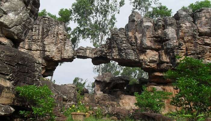
TIRUMALA: NATURAL ARCH, ANDHRA PRADESH

NEEDLE HOLE POINT, MAHARASHTRA

Source:

VALLEY OF FLOWERS, UTTRAKHAND

SANGESTAR TSO, ARUNACHAL PRADESH

The beauty, the charisma. A seeker, a traveler. One place, India. With geologically rich time-frame and attributes, this Highway led to one yet wondrous stop, in our journey to Beyond.

Comment below what you feel could make up to the list of Natural Wonders in India. After all, its Nature. Every little detail is a marvel.

REFERENCES

  • seeker, Amit ChandraA perpetual nature. “Ever Growing Living Root Bridges, Meghalaya – A Nature’s Marvel In The Northeast.” Living Root Bridges, Meghalaya: A Marvel Of Nature, 12 Mar. 2020, traveltriangle.com/blog/living-root-bridges-meghalaya/.
  • “Chir Batti.” Wikipedia, Wikimedia Foundation, 5 May 2020, en.wikipedia.org/wiki/Chir_Batti.
  • Wegeolize. “Nature’s Glory at St. Mary’s Island India.” Educating Nature and History, 3 Sept. 2017, wegeolize.com/2017/09/03/natures-glory-at-st-marys-island-india/.
  • Pal, Sanchari. “20 Natural Wonders of India We Bet You Missed In Your Geography Books!” The Better India, 30 Oct. 2017, http://www.thebetterindia.com/118998/lesser-known-natural-wonders-india-offbeat-travel-inspiration/.
  • “Chir Batti.” Wikipedia, Wikimedia Foundation, 5 May 2020, en.wikipedia.org/wiki/Chir_Batti.

A Knock on the Door to Past…

Recently crowned as a UNESCO World Heritage City, the walled city of Ahmedabad brims with stories packed inside its traditional housing complexes. Raised by Sultan Ahmad Shah-I in 1411 A.D., Amdavad, prospered well for as long as six centuries.

The city is margined by a wall that runs at the periphery of this cluster of civilization and thus is called a Walled city. There are a total of 12 gates at different checkpoints on the locus of this wall each having separate operational value. Earlier townships would come into being when provinces were ruled by emperors propagating a religion. Sultan Ahmad Shah-I originally set this up as an Islamic state and commissioned the construction of a Mosque. A mosque that leaves its viewers spellbound even today.

Mahurat Pol, the first pol

Division on the map was done following the population tally of a religious cult in a region. About 7 different religions (namely Hinduism, Islam, Buddhism, Christianity, Jainism, Judaism, and Zoroastrianism) and related communities co-exist here even today. The major demarcation being Pols

Pols are the gateways on streets, giving an identity to the subdivision of the locality it stands at the entrance of.

A total of 356 pols were built. These domestic neighborhoods are an excellent example of people respecting the societal norms to co-exist together.

This ancient township had structured civic areas for smooth sailing of their livelihoods. They enjoyed a harmonious community network with prearranged residential, commercial, industrial areas, Hospitals, Schools, Parks, etc. Each sub-local space had its respective religious sanctum as a highlight, proving religion defined the people around and not the other way round.

Psuedo walkway with fake parapet to confuse the invaders

The city had been prone to foreign invasions and attacks over the time, so they constructed pseudo pathways and rescue routes only known to the residents in case of a military emergency. These looked like abandoned door and interconnected all the pols.

Wind vane with opening to let the foul air escape from sewer

The lanes and community spaces were designed in such a way that they had a classical character. The entire city resembles a creased paper ball-like lane all along. The settlement looks as if the buildings are packed and stacked together bracing each other, a very similar concept of how their society worked, dependent on one another. Each cluster had public wells in a common courtyard. It served as an excellent area for daily rattle-tattle. This open space helped in basic ventilation through crisscross wind movement regulated by trees planted around. Folks around here have a usual routine of feeding birds and cows. Chabutras are miniatured canonical rotunda-like structures used to feed birds. Some wind vanes had a hole on the top of a pole which is connected to the sewer line of that area. The opening released the poisonous air from the sewer through the vent, over the busy streets thereby ensuring the efficient ongoing of lives.

The most noticeable thing about the houses are doors. Doors of different colors and patterns reflecting all kinds of myths and symbolism people believed in. Impressive lintels and diversely shaped brackets from different cultures narrate all that is to be known about the invasions and polity throughout the realm. People lived a very organic life. Apartments here were small, with timber beams supporting the roof and a planned water supply system. The plans of houses were very elementary. These buildings were all interconnected with Khadkis or inner entrances to pol. Wood and bricks were used considering the thermal comfort factors, but this resulted in wearing over time. Due to unstable political circumstances, there was a cyclic decay and growth. Thus, less scope for renovation and healthy maintenance.  

Vintage timber houses with iconic doors
Timber and Bricks used at construction materials
Chabutra along with a common meeting area

Buildings stacked together in proximity

Private residential mansions were usually owned by the heirlooms of higher society. They were called Havelis. The craftsmanship showcased on their facades showed the lushness of the Sultanate culture.

Swaminarayan Temple of Kalupur is a stone-built canvas in itself. Polished with bright colors on magnificently detailed multifoil arches, this shrine conditions a sense of peace to anyone who looks at it. The ringing of bells during aarti and Pigeons flying in the sky takes you back to a place where materialism has no value.

Walking deep into the labyrinth of pols, one will be witnessing white plastered stone-built Jain Derasars that only emit serenity and tranquility. The matrix-styled punctures on the stylobate of their pillars are very impressive and neat. These are considerably well maintained now than other build forms.

Swaminayan Mandir, Kalupur

Jami Mosque is another wonder treasured in this walled treasure chest of a city. The world-famous stone Jaali placed on the top of two pillars is a spectacle in itself. One can instantaneously feel the cut-off from the worldly shenanigans as soon as they emerge in the vast courtyard of this UNESCO World Heritage Site. The carvings on the mosque turned out to be of Saracenic Style which was a product of making the Hindu craftsman work along the lines of Persian Architecture.

The magnificent Jami Masjid shot at noon

People here love to come out in aangans like Ganpatram Chowk and listen to crowed and their chatter. These interactions ensure their quality of life. They surround themselves with people to witness ravages and cheers of life together. To relish and support the human connection and thrive well on it. Such a settlement, that grows old with history it carries deserves recognition and care. Or how else would we continue to drive on our HIGHWAY TO BEYOND?   

Ganpatram Chowk
Gateway to Swaminayan Mandir
It is the people who live and make a house, a home
References:

Welcome aboard!

Namaste there! This is Anvesha, who has always adored stories and thus her history books. But what she really loves is travelling to places of architectural interests.

I was in Jaipur once when I stood on the ramp and looked at the city and wondered, how colorful it would have been back when this fort was young. Architecture in turn is literature to me, a ballad painted all over the city. Primal built form here, eavesdropping into our lives ever since they’ve stood tall.

When we enter a space, we perceive certain emotions, conditioned by the way a structure envelops the viewer. The world prefers to call it Multi-sensory Architecture. I intend to handpick and decorate the page here on how a building responds to a user and vice versa. Scroll through the page while I take you to the highway and we’ll travel to the Beyond.